ArchAngel Fishing Charters
ArchAngel Fishing Charters is a fishing charter and guide service based in Newport, RI.
Gallery
Trip details
- Waters
- Narragansett Bay / Atlantic
- Fishing Types
- Inshore Fishing, Offshore / Deep Sea
- Trip Durations
- half-day, full-day
Fishing spots near ArchAngel Fishing Charters
Loads the full map of the fishing spots near this listing. We leave it off by default so the page opens fast on mobile data.
Angler reviews
What anglers are saying
- CChuck B· a month ago
I had an absolutely fantastic day on the water with Archangel Charters fishing for striped bass with Captain Mike and mate Josh. From the moment we stepped aboard, they were professional, welcoming, and clearly dialed in to the local fishery around Newport, RI. Mike put us on fish right away and kept adjusting throughout the trip to stay on the bite, which made for nonstop action on stripers and an all‑around awesome experience. Josh was constantly helping with rigs, netting fish, and sharing tips, making it easy and fun whether you were an experienced angler or new to charter fishing. The boat was clean, comfortable, and set up perfectly for inshore fishing, with plenty of room for everyone to fish without feeling crowded. You can tell Archangel takes pride in what they do—great communication, safe operation, and a genuine focus on making sure everyone has a memorable trip. If you’re looking for a high‑energy crew who knows these waters inside and out, I highly recommend booking a trip with Captain Mike and Josh on Archangel Charters.
- KKatelyn Schwebach· 2 months ago
Captain Mike and his crew know all the best spots, he has great equipment and we can’t recommend him enough. We had the best time and would absolutely recommend him to anyone wondering who they could go fishing with.
- MMike Conley· 3 months ago
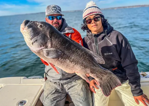
Ive fished on Mikes boat several times, usually fall tog trips. The experience has always been great and Mike puts you on the fish! He is one of the few super experienced charter captains in my area. The boat is one of the best as well, so spacious. Ive landed my PB tog on one trip, weighing 12-1/2 lbs. I would highly recommend ArchAngel Charters
- TThomas Day· 3 months ago
Amazing experience with Captain Mike. He truly cares about veterans and works hard to get everyone out on the water for a great day of fishing. Safe, fun, and well organized every trip. Highly recommend!
Reviews powered by Google. Content belongs to its respective authors.
Typical flow by month
1959 to 2026
The water at ArchAngel Fishing Charters typically runs highest in April, at a median 34 cfs, and lowest in September, at 6.5 cfs. The highest flow on record for any single day is 631 cfs, in 2010.
| Month | Typical (cfs) | Usual range (cfs) | Relative level |
|---|---|---|---|
| January | 23 | 15 to 34 | |
| February | 26 | 17 to 36 | |
| March | 31 | 23 to 43 | |
| April | 34 | 24 to 45 | |
| May | 25 | 18 to 33 | |
| June | 18 | 12 to 25 | |
| July | 9.1 | 5.7 to 17 | |
| August | 8.4 | 4.5 to 13 | |
| September | 6.5 | 3.5 to 11 | |
| October | 6.5 | 4.3 to 12 | |
| November | 10 | 6.0 to 19 | |
| December | 20 | 13 to 35 |
Typical is the median of each month’s daily median values, and the usual range runs from the median 25th to the median 75th percentile, across about 54 years of record. Statistics published by the US Geological Survey for Chipuxet River at West Kingston, RI (site 01117350). Conditions on any given day can fall well outside the usual range. Check the current reading before you go.
Current conditions
Waves
3.2 ft @ 6s
Wind
9 kt
Gusts 24 kt
Water
69°F
Air
66°F
Streamflow
20 cfs
Much above normal (93rd)
Water level
5.10 ft
Rain chance
14%
Forecast outlook
Forecast from Open-Meteo global models (NOAA & ECMWF). See full conditions →
More guides in Rhode Island
Also nearby
Other ways to get outside within about an hour of here.
Free tools
Your free outdoor toolkit

Everything Map
Listings, trails, spots, clubs and public land on a single full-screen map. Switch layers on and off, then tap any point for the details.
Open Everything MapFishing Spots
Browse 24,783 named waters, then read the state stocking record: species, size, and when.
Open Fishing SpotsRiver Explorer
Explore named rivers from the USGS hydrography dataset. Filter by water type or whitewater class.
Open River ExplorerRoute Planner
Drop stops on a map and watch distance and drive time add up. Export a GPX or share the link.
Open Route PlannerFishing Clubs
Browse local clubs with meeting info and how to join, or start your own for free.
Open Fishing ClubsLive Conditions
Real-time conditions spot by spot, pulled from public weather feeds, before you commit to the drive.
Open Live Conditions