Tri City Guide Service
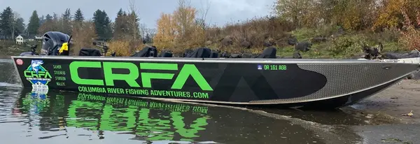
Tri City Guide Service is a fishing guide service based in Kennewick, Washington.
Gallery
Fishing spots near Tri City Guide Service
Loads the full map of the fishing spots near this listing. We leave it off by default so the page opens fast on mobile data.
- Ben Blair PondReservoirBenton County, WA
- Meadow Springs ReservoirReservoirBenton County, WA
- Snake RiverStreamFranklin County, WA
- Villard Pond (historical)LakeWalla Walla County, WA
- Burbank SloughLakeWalla Walla County, WA
- West ChannelChannelBenton County, WA
- J Line PondLakeWalla Walla County, WA
- Homly ChannelChannelBenton County, WA
Angler reviews
What anglers are saying
- AAlmo Pladson· 4 months ago
We had a great time fishing for Walleye with Tri Guide Services. Chris Benson owner/captain is very knowledgeable fishing on the Columbia River. Out of the three days we fished, not once was there a disappointing day on the river. We’re already planning our trip back next year with Chris. Almo Pladson
- PPatrick Glasco· 2 months ago
Hands down the best fishing guide i have ever used! We have been going with Chris every year for 10 years now and we have not once had an issue! His tackle is the best period and he is meticulous to make sure that a caught fish gets landed! My dad passed away this year and he caught his last fish with Chris and we did a special tribute on Chris boat this June which we'll never be forgotten! In my opinion 5 stars is truelly not high enough to rank him and we look forward to fishing the river with him again next year!!
- CChris Michael· 4 months ago
My second trip with Tri City Guide Service and can’t wait to book another trip. Chris is a great guide and a pleasure to spend the day with. I booked a combo Walleye/Sturgeon trip. The four of us caught a lot of Walleye and a 9’ Sturgeon (C/R). Chris provides great equipment, knows where to find the fish, and shows you how to catch them. I highly recommend him!
- PPatty Gaspar· 4 months ago
Every Spring Break I go somewhere with my grandsons. Usually it is the beach but now that they are 14 and 17 and are avid fishermen we went Walleye fishing with Chris as our guide. Chris communicated well, was timely and helpful (I never touched a worm or a fish but caught many). The boys wanted to learn about catching Walleye and they got their fill with tackle options, pole options, location options, even cleaning, freezing and cooking Walleye options. I learned too. Thank you Chris.
Reviews powered by Google. Content belongs to its respective authors.
Typical flow by month
1934 to 2026
The water at Tri City Guide Service typically runs highest in April, at a median 4,240 cfs, and lowest in July, at 1,410 cfs. The highest flow on record for any single day is 59,400 cfs, in 1934.
| Month | Typical (cfs) | Usual range (cfs) | Relative level |
|---|---|---|---|
| January | 3,080 | 2,180 to 4,760 | |
| February | 3,510 | 2,530 to 5,340 | |
| March | 3,950 | 2,780 to 5,700 | |
| April | 4,240 | 2,435 to 6,285 | |
| May | 4,210 | 2,390 to 7,340 | |
| June | 3,045 | 1,650 to 6,760 | |
| July | 1,410 | 1,100 to 1,810 | |
| August | 1,420 | 1,190 to 1,700 | |
| September | 1,780 | 1,520 to 2,075 | |
| October | 2,190 | 1,680 to 2,560 | |
| November | 2,425 | 2,040 to 3,100 | |
| December | 2,740 | 2,120 to 4,140 |
Typical is the median of each month’s daily median values, and the usual range runs from the median 25th to the median 75th percentile, across about 92 years of record. Statistics published by the US Geological Survey for Yakima River at Kiona, WA (site 12510500). Conditions on any given day can fall well outside the usual range. Check the current reading before you go.
Current conditions
Streamflow
1,540 cfs
Below normal (22nd)
Water level
4.00 ft
Water
70°F
High today
83°F
Wind
9 kt
Gusts 19 kt
Rain chance
0%
Week ahead
Forecast from Open-Meteo global models (NOAA & ECMWF). See full conditions →
More guides
Free tools
Your free outdoor toolkit

Everything Map
Listings, trails, spots, clubs and public land on a single full-screen map. Switch layers on and off, then tap any point for the details.
Open Everything MapFishing Spots
Browse 24,783 named waters, then read the state stocking record: species, size, and when.
Open Fishing SpotsRiver Explorer
Explore named rivers from the USGS hydrography dataset. Filter by water type or whitewater class.
Open River ExplorerRoute Planner
Drop stops on a map and watch distance and drive time add up. Export a GPX or share the link.
Open Route PlannerFishing Clubs
Browse local clubs with meeting info and how to join, or start your own for free.
Open Fishing ClubsLive Conditions
Real-time conditions spot by spot, pulled from public weather feeds, before you commit to the drive.
Open Live Conditions